Home - Seattle: Subduction Boundary

Wow - I'm finally home!
Although Seattle is an amazing place to live, I'm sad that my trip is over! Magnificent Everest, luxurious Saint Vincent, lovely New Zealand and spectacular Iceland truly gave me a great preview into our plate tectonics unit next year.
Of course, I highly recommend visiting Seattle because of it's interesting tectonic activity but it's also just a beautiful place to go. The Great Wheel and the Space Needle both offer exclusive views of downtown, Mount Rainier and surrounding landscape. Seattle is also located on a subduction boundary similar to Saint Vincent because there are two plates and one is subducting beneath the other. But differently than Saint Vincent which had two oceanic plates, this is a continental plate and an oceanic plate. The denser oceanic plate subducts beneath the less dense continental plate. Rather than an arc of volcanic islands, a mountain chain and volcanoes form.
In Seattle, the North American plate and the Juan De Fuca plate are along the subduction boundary. The Cascade Mountain Range containing Mount St. Helens and Mount Rainier is formed from this subduction. St. Helens' recent eruption in 1980 (also the most recent eruption in the United States) caused 57 casualties and covered 11 states in ash.
The earthquake activity in Seattle is quite major and as a matter of fact, we are overdue for a big earthquake right now! The most recent earthquake was in 2001 and had a magnitude of 6.1, which can be pretty damaging in an urban area. There were many injuries but because of our knowledge of earthquakes, hopefully we'll be safe for the next one!
To all you bloggers who have stuck with me throughout my entire fabulous journey: thank you! Also, if you are ever headed to Seattle and need some advice about what to do or just want to have a little snack with an old friend (me!), give me a holler at (206) 555-5555.

I'll be sure to blog on my next adventure now that I know how fun it really is!

-Kath ; )
http://www.frankfurnessresources.com/rickimages/Cascade-Mountains.jpg
http://www.globeimages.net/data/media/5/seattle_skyline.jpg

http://pubs.usgs.gov/fs/2000/fs060-00/images/subduction.jpg

Iceland: Divergent Boundary


Greetings all -
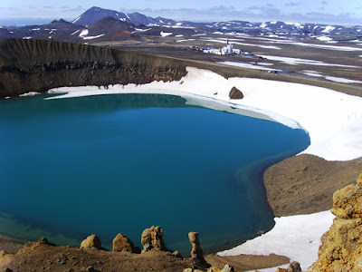
So sad to leave New Zealand but now we're here in the surprisingly lovely Krafla, Iceland (65°42'N, 16°48'W)! We arrived two days ago and have done nothing but explore since. We swam in a couple hot springs, hiked, biked and got to learn all about the divergent boundary that is Iceland! A divergent boundary is when there are two plates are moving away from each other. Here in Iceland, the Eurasian plate and the North American plate are splitting on the mid-ocean ridge causing a rift to form. As these two diverging plates are moving, they form a rift valley. As the two plates are moving away from each other, the less-dense magma coming from the asthenosphere (the part of the mantle in which the crust moves) rises up through the rifts (cracks). The rising magma obviously creates many active volcanoes. In this case, Iceland is located directly on a divergent boundary causing some really interesting things to happen! Krafla is in a fascinating location that is directly on the boundary causing it to be very active with 29 eruptions throughout history with 1984 being it's most recent episode. Along with volcanoes, divergent boundaries experience many earthquakes as the plates move apart. Krafla isn't the spot for the largest earthquakes in Iceland, the largest one there being 5.0 in 1976. But, the largest recorded earthquake in Iceland was a whopping 7.1 in 1963! Fun fact: Krafla is currently being used to produce geothermal energy!

I'm so sad to say this but this is our last destination until we're back home in Seattle : ( Leah and I have had the time of our lives traveling around the world in preparation for next year in science class. Thanks to all of the amazing people we met, you guys were truly awesome.

I'll write to you one last time when we're home!

- Kathy

(FYI: The first photo is of me and Leah at a hot spring!)

https://blogger.googleusercontent.com/img/b/R29vZ2xl/AVvXsEjo9VQY224II7jdorYNzCC3bWWNbhh4V1d5vAow-8x2mdtT5IIqFu89wr579Jq63FkudbZ2v4gXAj-qO_ls7NGHOgDf4LE8zOzSLpuGWmzHgdEZlFXBeErm75n2Z-IHuggUkAsBUxl6Fy0/s1600/Divergent1.gif
We're so sad we have to leave!! : (

http://www.shamskm.com/blogs/wp-content/uploads/2011/02/iceland_krafla_volcano.jpg

New Zealand: Transform Boundary

Heyo!
Kathy's back and she's in New Zealand (19°20'N, 81°22'W)!! Sad that we had to depart from Marty, Jill and the spectacular island of Saint Vincent : ( . We arrived two days ago and so far we've just relaxed and gotten used to our completely different surroundings! Right now I'm at lunch with our new tour guides, Brandi and Chase and my sis! They're teaching us all about what a Transform boundary is and what it does in New Zealand. They say that a transform boundary is when two plates are sliding past each other. A transform boundary can form mid-ocean ridges and faults. Here in New Zealand, the Pacific plate and the Australian plate are sliding past each other resulting in the Alpine fault.
Earthquakes are very common at transform boundaries. In the past 900 years, the Alpine fault has ruptured four times resulting in very high magnitude earthquakes (at least 8 magnitude)! Recently in July of 2012, there was an earthquake of 6.3 magnitude right off the coast of where I'm staying! Wow! Although volcanoes do not occur at transform boundaries, there are some in New Zealand due to the other types of plate boundaries here. The volcanoes are mainly on the North Island at Mt. Ruapahu and the last eruption was in 1996.
New Zealand is truly an amazing place to visit and I highly recommend it!!! The variety and presence of the different plate boundaries here make for some cool things to happen!

I'll talk to you soon,

Kathy


Saint Vincent: Subduction Boundary


Hey kiddos : )
Haven't been writing for a while but it's just because of all of this travel from Tibet to Saint Vincent (13°11'N,  61°15'W). It's been really sad having to say goodbye to Angie and Gleb, they were fantastic guides for our trip in Nepal. Now, while in Saint Vincent, we have two guides named Marty and Jill. So far they have taught us that Saint Vincent is part of an island arc in the Caribbean. They said that Saint Vincent is at a subduction boundary between two oceanic plates. When two oceanic plates converge, they are accompanied by an arc of volcanic islands on the overriding plate. Here, the oceanic crust of the South American plate is being subducted underneath the Caribbean plate causing a total of seventeen active volcanic islands and many earthquakes!
Historically, in 1839 and 1843 there were two megathrust earthquakes. It is unknown how large these earthquakes really were. Megathrust earthquakes are at subduction boundaries and can exceed 9.0 magnitude! That's HUGE! More recently on August 7, 2011 there was a 5.2 magnitude earthquake just off the coast of Saint Vincent.
Also, the volcano La Soufrière is right here on this island! La Soufrière is an active volcano and also the highest peak here in the island country of Saint Vincent and the Grenadines. Volcanoes form at subduction boundaries because the magma rises when water is released into the mantle. The release of water is called "dewatering" and lowers the melting point of the overlying mantle rock, which then undergoes partial melting and due to it's lighter density, rises. The latest eruption was in April of 1979. There were no casualties due to advance warning. There was an eruption on May 7, 1902 which killed 1,680 people (yikes!).
Wow, all of that information was a mouthful! I have to go for now because we're going on a little hike to get closer to this incredible volcano!
Talk to you later!!

- Kathy

(The first photo is of me and Leah relaxing on the nice beaches of Saint Vincent : ) The second photo is one I just took from where we're standing right now of La Soufrière! The third photo is showing how a volcano forms at a subduction boundary. )

http://en.wikipedia.org/wiki/File:Soufriere.jpg

http://en.wikipedia.org/wiki/File:Destructive_plate_margin.png

Himalayas: Collision Boundary

Greetings Blogosphere! : )
I wrote to you two days ago when we first arrived in Nepal and now I'm writing to you on day 3! Yesterday we slept in from a long day of traveling the day before, ate a late breakfast and got to know our guides for while we're in Nepal named Angie and Gleb. Right now I'm eating a late lunch in the hotel with Leah, Angie and Gleb. Angie and Gleb and teaching us all about the Himalayas and the collision boundary that is the Himalayas (27°59'N, 86°55'E). They taught us (and students this is what you'll be learning about next year so read closely!) that collision boundaries are where two continents are becoming welded into a single, larger continent. The collision of these two continents causes the crust at the boundary to be pushed upward into a mountain range. The Himalayas are a collision boundary where India and China are pushing against each other. The Indian subcontinent is pushing northward towards the Eurasian subcontinent at a rate of 5 centimeters per year. As the Himalayas are growing higher and higher, many earthquakes happen when the two plates push against each other. The most recent earthquake in the Himalayas was on June 22, 2008. It was a 3.7 magnitude in XiZang (The Nepal border region). On October 19, 1991 there was a massive earthquake in Uttaranchal, India that was a 7.0 magnitude! Hopefully while we're here we won't experience any dangerous earthquakes like that!
The attached picture shows a diagram of the collision boundary in the Himalayas. It shows that the crust is being pushed up forming the mountain range.

- Kathy
http://geolojay.com/blog/wp-content/uploads/2010/06/himalayan_plates.jpg

Introduction - The Start Of A New Journey

Hello internet!
Kathy here. I will be traveling around the world visiting four very interesting places. Each place is either a Divergent, Subduction, Collision or Transform tectonic plate boundary. This trip is in preparation for next year's plate tectonics unit (get excited students!) You may know my sister, Miss Leah, who teaches 7th grade science at Lakeridge Middle School. (Be sure to check out Leah's blog www.WULLHULLO.blogspot.com) We will be traveling together on this trip. We just landed in Nepal and will be studying Mt. Everest from Base Camp. It's too bad we can't climb to the summit but from what I can see right now, the Himalayas are absolutely spectacular.
The first picture is a selfie we took on the plane while gazing out the window! The second picture you see with this introduction is one that I took from the airplane of the Himalayas. The view from the plane was outstanding as you can see. WE'RE SO EXCITED : )
I have to go for now because we're pulling into our hotel called Hotel Himalaya but I'll keep you posted as much as possible!

Talk to you soon : )
- Kathy

Disclaimer: This trip and blog are both completely fictional and are for a science project!
Source: http://himalaya-foto.ru/images/himalayas-from-plane.jpg